
|
|
||||
|
|
|||||
| The Down East Circle Loop: Part 2: The Lower St. Lawrence River, the Gaspe, and New Brunswick |
||||
|
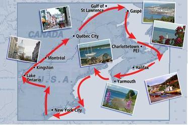
The Down East Circle Loop circumnavigates America’s northeastern states and Canada’s maritime provinces clockwise from New York City via the Hudson River, Erie Canal, the St. Lawrence River, Northumberland Strait, and returns from Nova Scotia and Maine on the Atlantic Coast, Buzzards Bay, and Long Island Sound. It is about 2,500 nautical miles in length, and welcomes the well-found cruiser with sights and cultures unlike any others in the hemisphere. In the previous article, we described the Lake Ontario to Quebec City stretch of the mighty St. Lawrence River.
Below Quebec the river widens and deepens. Soundings of 200’ and more become the norm. Breadth is measured in miles and tens of miles. Tree-covered mountains line the shore, rising sharply from river level to 1800 feet or more. In many places the combination of strong river and tidal currents with sudden variations in depth creates whirlpools, often a hundred or more yards across. No, they aren’t the kind you find in the bathtub, but they frequently nudged even our 85,000 lb. displacement boat here and there – quickly corrected by the dependable autopilot.
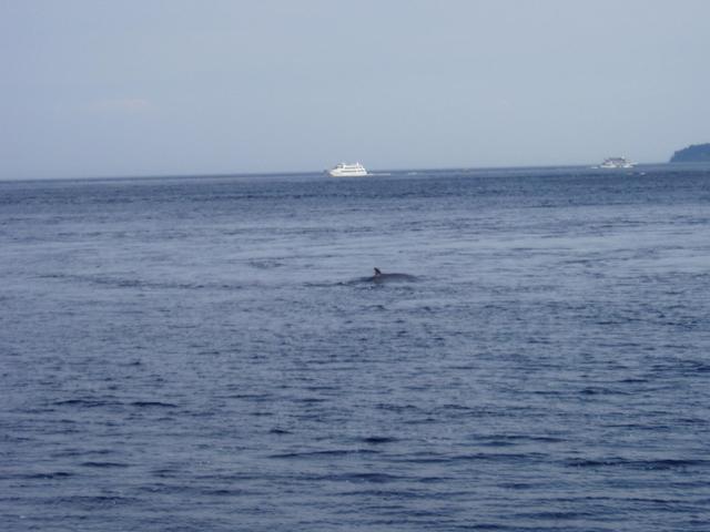
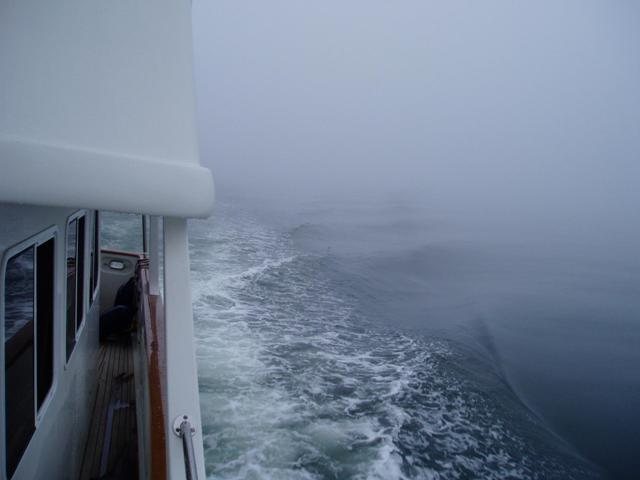
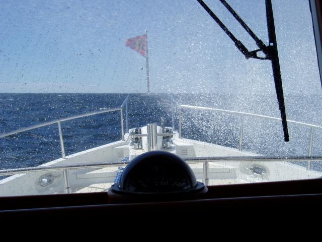
We are ever watchful under way, but in such big water, the boat and her systems usually do a better job of handling course keeping than the helmsman if given a chance. Timing of tides is a big thing. Well done, there are places in this stretch that can give you 5 knots of help. Poorly done, well - you can figure. The Canadian Hydrographic Service book was invaluable in our planning for this fact of cruising life in the region. Our destination was Tadoussac at the mouth of the Sagueney River. For the first time, fog that had been threatening closed in tight and we ran in IFR conditions. The GPS-driven chart plotter and the radar kept us in the right place at the right time. It was never a surprise to come upon a buoy or a boat that we had been tracking. At one point, the current turned back on us and created fascinating chop and wave action as the flooding tide decided to reverse the natural flow of the river. Just 4 miles from our destination the fog magically lifted and the towering mountains that guard the Sagueney River at Tadoussac appeared, as did a fleet of whale-watching boats. We were in what many believe to be the whale-watching capital of North America. Seven species are known to haunt this krill- and mackerel-rich confluence of the St. Laurence and the Sagueney. It is home to pods of the rare and endangered white Beluga whales.
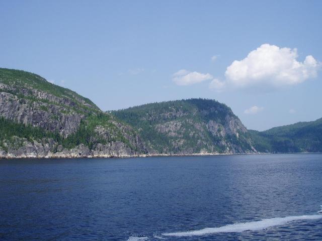
Here, the St. Lawrence is typically 250-300’ deep. The water temperature was just 48°F! The Sagueney River is actually a fjord. On the sides, sheer cliffs rise to heights of 900-1,200 feet. They plunge into the river with no attempt to stop, and even just 50’ from shore it is over 100’ deep. Our depth sounder gave up at 600’, but the charts told us it was close to 900’ deep.
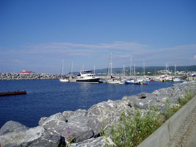
We docked at Marina Tadoussac and walked around the seasonal town. Like everything else we saw in Quebec, it is neat, friendly, and very French. On the rocks at river’s edge we joined many just sitting there and watching whales dive and spout a mere hundred yards off shore. Amazing.
A return of pea-soup fog foreclosed any chance to see that night’s Blue Moon. It lifted around 0900 the next morning (so we thought) and we took off for Rimouski nearly 60 miles distant and fully across to the south shore of the St. Lawrence. Within 10 minutes the 'soup' returned, and except for two whales that soon surfaced about 100’ away, all we saw for 6 hours was the bow of our boat and a fading wake. Waypoints were imaginary until the buoy signaling the entrance to Rimouski harbor emerged from the mess less than 100’ ahead of us. We turned and ran the GPS range 2 miles to the harbor, which suddenly appeared out of the nothing we had been floating through for so long. It was good to be docked, even in the rain. Like most of the other stops we made, it was a delightful marina, with good provisioning nearby.
Two more days of easy, smooth cruising in clear weather found us in Sainte-Anne-des-Mont, a quaint village where we tied up on the face dock between two sailboats with at least a foot of clearance bow and stern! Walking is the normal mode of transportation for the cruiser. It is seldom more than a mile to whatever provisioning or destination that’s required. And, it does one good to be off the boat and have a chance to immerse in the local color, to say nothing of the benefits to your heart and waistline. We walked all over Sainte-Anne-des-Mont and discovered a huge park system, an IGA grocery, library, internet café, and a great fish market where we bought a 1.75kg lobster that became the centerpiece of a delicious dinner. Another time, we would stay longer and hike some of the mountains in the provincial park nearby. Marinas are located in harbors every 35 – 50 miles along the south shore of the lower St. Lawrence. There is always room, as transients are infrequent. Anchoring in the river is out of the question owing to the depths and currents even close to shore, to say nothing of the exposure to tens of miles of fetch. Huge seawalls of massive granite blocks surround the docks and anchorage of all the harbors along the lower St. Lawrence. They are commonly 10-15’ above the water, even at high tide. One feels snug, but closed in for lack of vista. It gave us a sense of just how wild the river might get in a bad blow. Larger vessels may get surprised to find that some marinas provide only 15 amp service.
Calm and quiet weather invited us to push the 88 miles to Riviere de Reynaud the next day. The further one travels down the St. Lawrence, the more awesome is the topography. Towering cliffs hundreds of feet high plunge to the sea, yet only a half-mile offshore it is 200-300’ deep. The St. Lawrence is 30 miles wide and growing at this point, and one must remind oneself that technically, it is still a river. On a regular basis, smaller rivers flow through a valley into the mighty St. Lawrence, and there a village springs up. Each has a huge church; each has a cross high on a nearby hillside. Extensive windmill farms, some with over 300 towers, are commonplace. With the prevailing winds, they generate megawatts of electricity from a pollution-free, limitless, and forever-renewable energy source, 24/7.
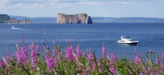
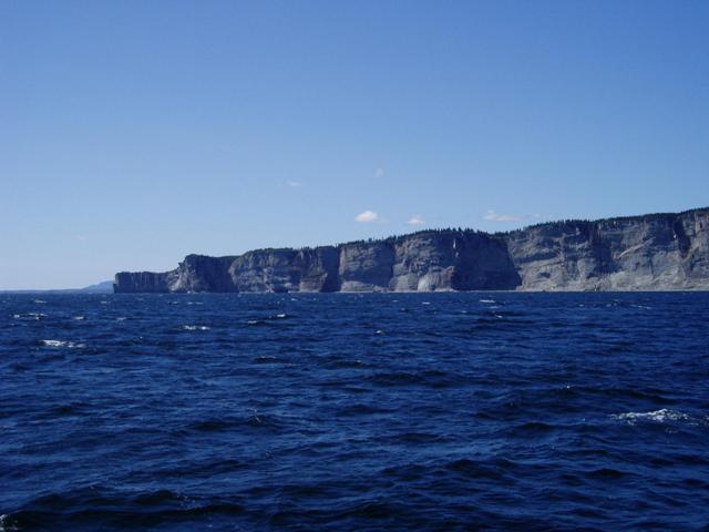
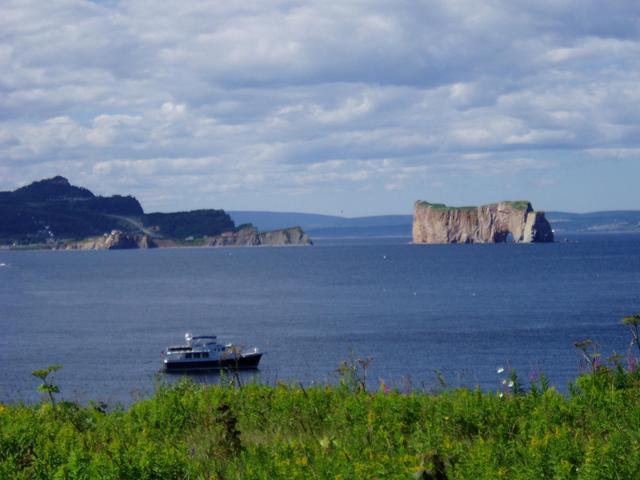
At Cap de Madeline we reached the northernmost point of our summer cruise at latitude N44°16', some 616 miles north of Annapolis! On watch, Andrea spotted whales frequently, as well as many porpoises. A huge humpback spouted right in front of us and as we slowed to a stop, two more joined and spouted over and over. The video was burning! Finally, they dove and one gave the famous tail in the air salute... It was clear but blowing as we left Riviere de Reynaud to go around the tip of the Gaspe Peninsula. The ride was fine and we passed Cap de Gaspe around 1030, one of the most dramatic coasts of sheer cliffs we saw. Fifteen miles further we passed the famous Perce Rock with its huge hole. This landmark is measured at 290 feet high, and claimed to be the most-photographed natural feature in Canada. Visitors can reach it using a sandbar that dries at low tide. The park service is there to hustle everyone back to the mainland before the rising tide cuts off the route.
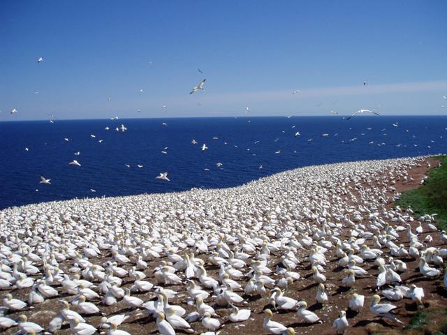
After anchoring just off Ile de Bonaventure, a national park just two miles from Perce, we hiked across to the eastern cliffs that are a rookery for gannets. As Carl Sagan would say, there were billions and billions of them; we think there were only about a million but who’s counting. It was noisy and a bit whiffy, but fascinating. When we got going, the seas had changed to be in our face at 4-5’ opposing the tide so we bobbed the 25 remaining miles to Chandler where we snugged in for an early evening. This would be our last night in French-speaking Canada. It also marked an approximate mid-point in the loop, giving us pause to reflect on what we had learned and experienced thus far. In a way, the list was short.
One conclusion we reached is that Canadian waters are worth every effort to experience. Another is that Canadians set a standard for hospitality that we Americans could aspire to – both afloat and ashore. And a third is that they also seem to lack some things we have plenty of including litter, police presence, crime, and guns. Could there also be some correlation to the fact that they also lack American bourbon? You can get any kind of Scotch or Canadian at the well-stocked, provincially controlled stores, but Jack, Jim, or Granddad – forget it! Our cruising guide spoke encouragingly about the nice ride to be expected across the 30 miles of Chaleur Bay from the southern coast of the Gaspe to the northern coast of New Brunswick. Not the day we crossed! Shortly after we cleared the lee of protective headlands we caught unforecasted 20-25kt SW winds that were fetching 40 miles up the bay and delivering 3-5’ square beam seas with tons of whitecaps. Secure in the pilothouse, and with stabilizers working overtime, we appreciated Celebrate all the more. Weather forecasts are broadcast continuously on the same VHF channels as in the US. The maritimes are subdivided into 15 regions, and one must attend to which forecast is applicable at the moment. Reports alternate between French and English every 20 minutes. Unlike our own NOAA updates, the Canadian service is notably lacking in terms of sea state. Cruisers must listen to wind forecasts and check the fetch and currents to make their own projections. All units of measure are given in metric terms. Wind speed is given in km/h, temperatures are in degrees n Celsius.
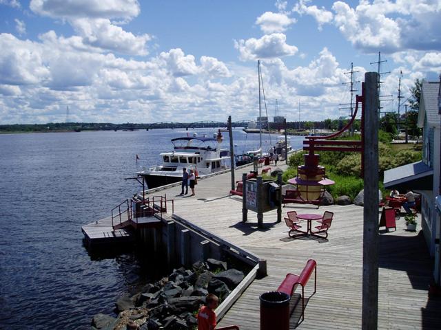
In August and September, the clear weather is ideal for cruising. Fog is rare – in fact, we only needed our radar twice. Mornings are almost always calm. Then, nearly every day in early afternoon southwest winds of 10-15 knots pipe up. This pattern can be played to balance smooth cruising with plenty of shore time to explore and enjoy the countryside. As pleasant as this is, we donned our fleece on a regular basis in the most northern segments of our route as daily highs were often in the upper 50s and low 60s. Locals claimed, and we believed them, that 2004 was an unusual cool summer. Shippigan was a welcome respite from the square waves of Chaleur Bay, but clearly an industrial strength fishing village with limited attractions, and even more limited facilities for recreational cruisers. We threaded our way out of the “gully,” which is what New Brunswickers call inlets, into Northumberland Strait and were delighted to find it fairly flat. On we went to our destination a dozen miles up New Brunswick’s Miramachi River. There was an instant change in topography, language, and cruising waters. Land was flatter – even seashore-like with long beaches and dunes. Depths were measured in the tens of feet, not hundreds. English became the primary language. As visitors, we tied up for free at Ritchie Wharf, Miramichi revitalized waterfront. We can’t say enough about the city – not only because of all the conveniences (grocery, post office, library, hardware, Alcool NB, gym, restaurants, etc., within 2-5 blocks), but also because of the people. As in other towns, we got a lot of complimentary attention, and everyone started the conversation with “Welcome to the Miramichi!” And they meant it. We quickly learned that our own mistaken pronunciation (Mir-a-ME-chee) had to be altered to Mir-a-ma-SHEE to be proper.
All ages, all types, and all friendly and sincere. Andrea struck up a very brief conversation with a passing couple one morning, and early that evening they crossed our path and presented a hot-out-of-the-oven homemade blueberry pie! It was delicious desert (and breakfast) for a couple days. It was interesting to suddenly be in an English-speaking community after nearly three weeks embarrassing ourselves with pidgin-French and hand gestures. While happy to be able to read a newspaper at last, we were aware that we missed the one aspect that above all gave us the sense of foreign adventure – the language. It seemed to define the turning point that signaled the beginning of our return. But we looked forward to more discovery and adventure as we laid plans for crossing Northumberland Strait to Prince Edward Island, and beyond to Nova Scotia, the Bay of Fundy, and the southern shores of New Brunswick. To be continued . . .
|
||||
| ||||
| Copyright (c) MDT Consulting, LLC 2007. All rights reserved. | Visit the Selene manufacturer's web site | Use & Privacy Policy | Contact us | |